
The geography of Pittsburgh, PA, is a tale of two forces: its iconic trio of rivers and the Appalachian Plateau’s rolling hills. What challenges and opportunities do these physical contours present for the city known as the ‘Steel City’?
This article navigates through the geography of Pittsburgh, PA, focusing on how its waterways and topography have forged its neighborhoods, influenced its development, and continue to define the living experience of its inhabitants.
Key Takeaways
- Pittsburgh is characterized by its hilly landscape, which has contributed to the development of unique infrastructure like public staircases and steep streets, shaping the city’s accessibility, connectivity, and identity.
- The Allegheny, Monongahela, and Ohio Rivers play a central role in Pittsburgh’s geography and identity, influencing everything from the city’s layout and cultural life to its economic development and environmental challenges.
- Pittsburgh’s urban planning, neighborhoods, and economy have been significantly shaped by its geography, with efforts to transition from an industrial past to a diversified economy focusing on sectors such as services, medicine, and higher education.
Pittsburgh, PA’s Hilly Terrain
The hills of Pittsburgh, often referred to as the city’s “staircases to the stars,” have an undeniable impact on the city’s layout. As a result of the city’s location on the Appalachian Plateau, these hills have influenced the positioning of buildings, sewer lines, and even entire neighborhoods. The steep slopes have not only presented unique challenges in terms of accessibility and connectivity but have also given the city its unique character.
This hilly terrain has given rise to two prominent features of Pittsburgh: public staircases and steep streets. These features have not only become integral parts of the city’s identity but have also played a significant role in shaping the experiences of its residents. We will now examine these distinctive features of the Steel City in greater detail.
Public Staircases
The history of public staircases in Pittsburgh dates back to the late 19th and early 20th centuries. These staircases, initially built to facilitate the movement of European immigrants and steel industry workers, have now become a part of the city’s architectural identity. Today, Pittsburgh boasts nearly 800 city-owned steps, earning the title of the town with the highest number of public staircases in the United States.
For residents in hilly areas, these staircases are a lifeline, offering a secure method to traverse the steep inclines. With each step, they reveal a unique aspect of Pittsburgh, from zigzagging paths to stunning panoramic views of the city. Notably, the staircases have also adapted to the city’s climate, becoming essential during the challenging winter months.
Pittsburgh’s public staircases, such as the Mosaic Steps on the South Side and the Steps of Pittsburgh, connect surrounding mill towns and neighborhoods. They are not only a testament to the city’s ability to adapt to its geographical challenges but also a symbol of Pittsburgh’s resilience and determination.
Steep Streets
Similar to the public staircases, the city’s steep streets bear witness to Pittsburgh’s hilly landscape. These streets, built on steep slopes, are a daily reality for the city’s residents. They present challenges, particularly during the winter, when navigating them requires more than just good tire tread. However, these challenges have not deterred Pittsburghers, who have found ways to adapt and thrive.
The steep streets, such as Canton Avenue, add to the distinctive quality of Pittsburgh. They provide a stark contrast to flatter cities and showcase the city’s diverse range of street infrastructure. Neighborhoods like Beechview, with its particularly steep streets, exemplify the unique character of Western Pennsylvania’s topography.
While the steep streets may pose challenges, they also contribute to Pittsburgh’s charm. They serve as a constant reminder of the city’s geographical uniqueness and resilience, making Pittsburgh an exciting city to explore, whether on foot, by bike, or by car.
The Three Rivers
The Allegheny, Monongahela, and Ohio rivers of Pittsburgh are more than just geographical features; they form an integral part of the city’s identity. These rivers have shaped the city’s landscape, served as crucial transportation routes, and even influenced its naming. General John Forbes, recognizing the strategic importance of the rivers, named the city after the British statesman William Pitt the Elder.
Historically, these rivers have played a pivotal role in shaping the city’s development. Landmarks such as Fort Duquesne, located at the confluence of the three rivers, bear testament to the city’s rich history and the rivers’ integral role in it. Today, these rivers not only shape the city’s physical layout but also influence the development of institutions like Carnegie Mellon University.
At Point State Park in downtown Pittsburgh, the Allegheny and Monongahela rivers converge to create the Ohio River. This confluence serves as both a geographical landmark and a symbolic link in the city’s relationship with its waterways. It is a reminder of Pittsburgh’s industrial past as the “Steel City” and its present as a vibrant, thriving city.
Allegheny river
The Allegheny River, being one of Pittsburgh’s defining three rivers, has considerably influenced the city’s geography and development. Its course through the town has provided opportunities for water recreation, sustained aquatic ecosystems, and affected the city’s physical features.
Landmarks along the river, such as Phipps Conservatory and Botanical Gardens, Mount Washington, and PNC Park, offer glimpses into the city’s rich history and vibrant culture. The river has also influenced the city’s transportation and infrastructure, serving as a navigable waterway and influencing the construction of bridges, locks, and dams.
The Allegheny River spans a total of 325 miles, serving as a crucial lifeline for Allegheny County and the city. It has played a significant role in the city’s development, especially during the American Industrial Revolution, serving as a transportation pathway for goods and resources. It’s not just a river; it’s a testament to the city’s resilience and growth.
Monongahela river
Mirroring the Allegheny, the Monongahela River has also played a vital part in molding Pittsburgh. It has served as a natural asset, contributing to the establishment of the region and shaping the city’s development. Its confluence with the Allegheny River to form the Ohio River has not only influenced the city’s geography but also its economy and wildlife.
With its origins in West Virginia, the Monongahela River is fed by several tributaries that contribute to its flow and relevant watershed. It sustains a diverse range of aquatic life, including various species of bass, catfish, and bluegill. It also serves as a habitat for wildlife such as the black bear.
Through its role in the city’s geography and history, the Monongahela River continues to shape Pittsburgh. It serves as a constant reminder of the city’s rich past and a symbol of its vibrant present.
Ohio River
The Ohio River, rounding out Pittsburgh’s river trio, attests to the city’s distinctive geography. Formed by the confluence of the Allegheny and Monongahela rivers, it plays a significant role in the city’s geography, history, and development.
The river traverses or forms the boundaries of six states, fed by several significant tributaries, showcasing the expansive reach of Pittsburgh’s waterways. Its influence extends beyond the city’s borders, shaping the landscape and influencing the development of neighboring regions.
The Ohio River’s impact is not limited to geography and development. It also plays a crucial role in the city’s recreation, with riverfront parks and walking trails providing access to the river’s beauty. In the following sections, we will examine these recreational areas along with the city’s infrastructure that facilitates the enjoyment of the river’s beauty by residents and visitors.
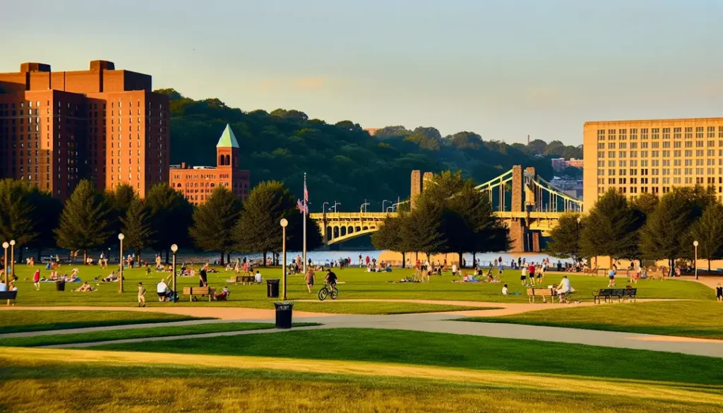
Riverfront Parks and Trails
In Pittsburgh, riverfront parks and trails like the Three Rivers Park and the Three Rivers Heritage Trail form a continuous network linking various parts of the city. These spaces offer breathtaking vistas of the Monongahela, Allegheny, and Ohio Rivers, thereby augmenting the scenic beauty of Pittsburgh.
These spaces are more than just spots for leisure activities. They serve to:
- Connect communities
- Offer residents a secure and effective means of navigating the terrain
- Provide numerous opportunities for outdoor recreation
- Foster a sense of community among the city’s residents
These parks and trails, located in downtown Washington, are integral to the city’s lifestyle.
Whether it’s a stroll along the trail, a bike ride with a stunning river view, or a picnic in the park, these riverfront spaces provide a chance to slow down, appreciate nature, and truly experience the beauty of Pittsburgh.
Bridges and Tunnels
Bridges and tunnels form vital components of Pittsburgh’s city connectivity, rendering the city’s hilly landscape and rivers traversable. With 446 bridges, Pittsburgh has rightly earned the title’ City of Bridges’. These bridges not only link isolated areas within the city but have also become iconic elements of the city’s skyline. Bridges like the Three Sisters Bridges and the Smithfield Street Bridge have become critical landmarks in the city, each bearing its unique tales of the city’s history and progress. The city’s tunnels, such as the Fort Pitt and Squirrel Hill Tunnels, also play a significant role, enabling transportation across the city’s challenging topography and connecting different areas of the city.
Thanks to these bridges and tunnels, navigating Pittsburgh offers a unique experience. They serve as a constant reminder of the city’s geographical challenges and the ingenious solutions that have emerged to overcome them.
Climate and Weather
Pittsburgh experiences a climate marked by seasonal variations, featuring warm summers and chilly, snow-filled winters. These variations are influenced by the city’s geography, particularly its distance from large bodies of water, which contributes to temperature fluctuations and the unique climate Pittsburgh experiences.
The city experiences an average annual snowfall of 27.7 inches and an average annual precipitation of 38 inches, which includes both rain and snow. The average temperature in the summer season is approximately 80°F, while in winter, it is around 41°F.
These seasonal variations greatly influence the lifestyle and activities in the city. From snow sports in the winter to water activities in the summer, the city’s climate provides a range of outdoor activities for residents and visitors alike.
Seasonal Activities
Pittsburgh’s changing seasons usher in a wide variety of outdoor activities in the western Pennsylvania region, particularly in the Pittsburgh metro area. From biking trails to beaches, the city offers ample options for outdoor recreation throughout the year.
Summers in Pittsburgh are filled with:
- Music concerts
- Visits to waterparks
- Kayaking
- Baseball games
- Festivals and events that celebrate culture, music, and local crafts.
The city’s public parks also play a significant role in enhancing these seasonal activities. From hiking in the spring to enjoying the fall foliage, these parks offer enjoyable activities for all age groups.
Green Spaces and Natural Reserves
Pittsburgh hosts a variety of green spaces and natural reserves that enhance the city’s livability and endorse environmental sustainability. These green spaces not only provide venues for outdoor recreation but also play a crucial role in climate regulation and biodiversity conservation.
From Emerald Park to Deer Lakes Park, these green spaces serve as carbon sinks, absorbing rainwater and alleviating air pollution. They are also home to a variety of wildlife, including white-tailed deer, cottontail rabbits, and various bird species.
These green spaces and natural reserves not only enhance the city’s beauty but also contribute to the health and well-being of its residents by preserving natural resources. They provide a quiet retreat from urban life and serve as a reminder of the city’s commitment to environmental sustainability.
Point State Park
Point State Park occupies a prominent position among Pittsburgh’s green spaces. Located at the confluence of the city’s three rivers, the park offers recreational areas for downtown Pittsburgh’s workers, visitors, and residents. The park is home to several historical landmarks, including the Fort Pitt Museum and the Fort Pitt Block House, adding to its charm.
The park offers a range of activities for visitors to enjoy, including:
- hiking
- mountain biking
- horseback riding
- picnicking
The park is also home to indigenous species such as the bluebird, monarch butterfly, and downy woodpecker, contributing to the park’s ecological diversity. Through its recreational opportunities and historical landmarks, Point State Park fosters a deeper connection between the city’s residents and its unique geography.
Urban Development and City Planning
The city’s geographical challenges have shaped the evolution of Pittsburgh’s urban development and city planning. The city’s topography, characterized by hilly terrain and three rivers, has shaped its urban development, influencing the layout of neighborhoods and transportation infrastructure.
The city’s planning dates back to the 1890s and continued through World War II, with the establishment of the Urban Redevelopment Authority in 1946 marking a significant milestone in its urban development. Today, city planning aims to manage the challenges posed by its geography, from managing taxation to implementing environmentally conscious regulations.
Through careful planning, the city extends east, transforming its geographical challenges into unique features, creating distinctive neighborhoods and districts that add to the city’s charm, including the Golden Triangle area.
Neighborhoods and Districts
The city’s unique geography and history are reflected in Pittsburgh’s neighborhoods and districts. From Lawrenceville to Shadyside, each community has its special character, shaped by the city’s hilly terrain and its rivers. These neighborhoods offer a diverse range of experiences and attractions. Whether it’s the vibrant arts scene in Lawrenceville or the bustling business district in Shadyside, each neighborhood adds a unique flavor to the city’s cultural tapestry.
These neighborhoods are more than just areas on a map. They are vibrant living spaces that reflect the city’s past, present, and future. They are home to the city’s residents and are a testament to Pittsburgh’s resilience and adaptability.
Economic Influences

The city’s geographical location has significantly influenced Pittsburgh’s economy. From its early days as a hub for the steel industry to its current status as a diverse economy, the city’s geographical position has influenced its economic trends.
The city’s rivers were a vital transportation pathway for goods and resources, facilitating the growth of industries and trade. As the steel industry declined, the city’s location and infrastructure facilitated the development of a diversified economy, focusing on:
- services
- medicine
- higher education
- tourism
- banking
- corporate headquarters
Today, the city’s economy is as diverse as its landscape. Pittsburgh’s economy includes various industries, such as:
- Education
- Tourism
- Medicine
- Finance
This diverse economy reflects the city’s ability to adapt to changing circumstances and capitalize on its geographical advantages, accommodating the needs of the city’s population.
The transition from the Steel Industry
The city’s shift from being a steel industry hub to a diverse economy was guided by both its geography and the decline of the steel industry. The city’s riverine geography and proximity to coal deposits played a crucial role in the establishment and expansion of the steel industry.
However, the decline of the industry due to global competition, economic changes, and labor disputes led to a shift in the city’s economic focus. The city’s infrastructure, shaped by its geography, facilitated the growth of a diversified economy, focusing on:
- services
- medicine
- higher education
- tourism
- banking
- corporate headquarters
Today, Pittsburgh’s economy is a testament to the city’s resilience and adaptability. From steel mills to healthcare facilities, the city’s economic landscape reflects its ability to transform challenges into opportunities.
Environmental Challenges and Solutions
Pittsburgh’s geography poses unique environmental challenges. From air pollution to the impact of climate change, the city’s geography has influenced its ecological issues. However, the city has also taken initiatives to address these challenges and improve its environment.
Revitalization efforts such as the downtown greening project by the Conservancy and the restoration along the North Shore by Riverlife have been successful in addressing these challenges. In addition, the city has implemented policies and initiatives to address environmental inequities and promote environmental responsibility.
Through these efforts, Pittsburgh is working towards creating a sustainable environment that not only benefits its residents but also contributes to the global effort to combat climate change.
Air Pollution and Revitalization Efforts
Air pollution is one of the significant environmental challenges in Pittsburgh. The city’s industrial past and geographical features have contributed to this issue. However, revitalization efforts are underway to address this problem and improve the city’s air quality.
The city’s industrial past and geographical features have contributed to this issue. However, revitalization efforts are underway to address the problem and improve the city’s air quality. These efforts include greening and beautification projects, smoke control ordinances, and brownfield site reclamation.
These efforts show Pittsburgh’s commitment to improving its environment. Despite the challenges, the city continues to work towards finding solutions, demonstrating its resilience and commitment to creating a healthy environment for its residents.
Cultural Identity and Lifestyle
The city’s geography has shaped Pittsburgh’s cultural identity and lifestyle. From the hilly terrain to the three rivers, the city’s geography is reflected in the residents’ way of life. From outdoor activities to community events, the city’s unique geography influences the way Pittsburgers live, work, and play.
The city’s diverse communities, such as the Polish community, have also contributed to its cultural identity. These communities have influenced various aspects of the city, including:
- music
- sports
- cuisine
- craftsmanship
This adds to the city’s rich cultural tapestry.
Whether it’s enjoying a bike ride along the river or attending a music concert in the park, the city’s geographical features offer countless opportunities for residents and visitors to experience the vibrant culture and lifestyle of Pittsburgh.
Sports and Recreation
In Pittsburgh’s cultural identity, sports and recreation play a pivotal role. The city’s geographical features have influenced the range of sports and recreational activities available in the city.
From football with the Pittsburgh Steelers to baseball with the Pittsburgh Pirates, sports are an integral part of the city’s culture. The city’s sports venues, such as PPG Paints Arena and Acrisure Stadium, are intricately woven into the city’s architectural fabric, enriching Pittsburgh’s distinctive landscape.
Whether it’s cheering for the home team at a football game or enjoying a stroll along the river, sports and recreational activities offer residents and visitors a chance to experience the city’s vibrant culture and spirit.
Impact of Geography on Pittsburgh’s Housing Market
In the midst of Pittsburgh’s rolling hills and rivers, the city’s housing market presents a fascinating study of geographical influence on real estate. As we delve into the intricacies of Pittsburgh’s neighborhoods, it becomes evident that the city’s hilly terrain and proximity to waterways are not just mere backdrops but active shapers of the housing landscape.
In areas like Mount Washington, renowned for their steep slopes and panoramic city views, the real estate market thrives on the unique appeal of hillside living. These neighborhoods often feature homes with distinct architectural styles that embrace the topographical challenges, offering residents stunning vistas and a sense of exclusivity. On the other hand, neighborhoods closer to the rivers, such as the North Shore and South Side, capitalize on their waterfront locations. These areas have seen a surge in demand for properties, driven by the allure of riverside living and the convenience of easy access to downtown Pittsburgh.
Moreover, the city’s distinctive geography has led to a diverse range of housing options, from historic row houses nestled in tight-knit hillside communities to modern apartments and condominiums overlooking the rivers. This diversity not only caters to a wide spectrum of housing preferences but also reflects the city’s evolving identity, balancing its industrial heritage with contemporary urban living.
However, the unique topography also presents challenges. In certain hilly neighborhoods, issues like limited parking and accessibility impact real estate values and living experiences. Similarly, areas near the rivers must contend with environmental considerations such as flood risks. Addressing these challenges requires innovative urban planning and infrastructure development, ensuring that the charm of Pittsburgh’s geography translates into sustainable and livable housing solutions for its residents.
As Pittsburgh continues to transform and grow, understanding the interplay between its geography and housing market becomes crucial for both prospective homeowners and urban planners. This dynamic relationship highlights the importance of considering geographical factors in urban development, shaping a city that harmoniously blends its natural contours with human habitation and progress.
Summary
From its hilly terrain to its three rivers, Pittsburgh’s unique geographical features have significantly shaped its development, culture, and lifestyle. The city has transformed its geographical challenges into special features, creating an urban landscape that is both diverse and vibrant. Whether it’s navigating the steep streets, exploring the city’s green spaces, or enjoying a game at one of the city’s sports venues, Pittsburgh offers a unique blend of natural beauty and urban charm. As we’ve seen, the city’s geography is not just a backdrop but a dynamic force that shapes the city’s identity and lifestyle.
Frequently Asked Questions
What is the geography of Pittsburgh, Pennsylvania?
Pittsburgh, Pennsylvania, is situated west of the Appalachian Mountains in the Appalachian Plateaus Province, with a relatively flat surface dissected by drainage from the three principal rivers of the region – the Allegheny, Monongahela, and Ohio.
What is the geology of Pittsburgh?
The geology of Pittsburgh is characterized by the Pittsburgh Low Plateau Section, which has a smooth to undulating surface and consists of shale, siltstone, and sandstone. This creates narrow valleys with a dendritic drainage pattern.
What are the three rivers in Pittsburgh?
The three rivers in Pittsburgh are the Allegheny, Monongahela, and Ohio, providing beautiful scenery and recreational opportunities.